
Introduction
Clean safe water is one of those items most of us take for granted but it is still not available in many parts of the world. Until relatively recently, water was in short supply, especially for stock in the wheat and sheep farming belt of the semi-arid northwest of Eyre Peninsula. That the situation improved was due largely to government measures, but local conservation schemes also proved useful.
Farming on north-western Eyre Peninsula: potential and problems
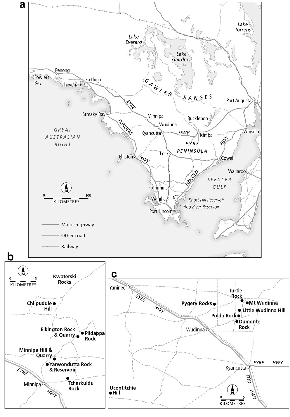
In 1906, Mr Edward Britten Jones, the Government Valuer in the Survey Department, was sent to Eyre Peninsula (Figure 1a) charged with assessing the agricultural potential of the area. Doubtless bearing in mind Goyder’s Line (e.g. Jeffery, 2001; Meinig, 1961; see also Department of Lands, South Australia, 1986), which was based on the distribution of natural vegetation and which passes through the area, the north-western reaches of the Peninsula were recognised as semiarid and deemed to be located at the northern limit of agriculture. Added to the problem of low rainfall were its unreliability and its relative ineffectiveness in a streamless karstic landscape (Bourne & Twidale, 2016).
_main_centres_referred_to__position_of_main_transport_arteries_and_the_.jpeg)
Notwithstanding, Jones (1906) reported that, given adequate access and water supply, and bearing in mind the value of superphosphates, the north-western district around the present towns of Minnipa and Wudinna, was one of high agricultural potential (Jones, 1906). With admirable foresight, the Government decided to establish farms to provide for research and advice in the recognised agricultural districts of the State (Radcliffe, 2007). Staff appointed would investigate selected agricultural problems and liaise with local farmers. In 1914, seeking a suitable site for a government farm in the north-west of Eyre Peninsula, the then Director of Agriculture, Professor A.J. Perkins (1917), selected a holding at ‘Yarwondutta’ (Figure 1b). The place name had been noted on a sketch map produced by Hack (1857), who also reported water in basins associated with granite outcrops in the area (see also Eyre, 1845, pp. 119–200). The proposed farm included two prominent granite outcrops as well as sundry bedrock platforms. It was situated near the new railway settlement of Minnipa (1913) and was expected soon to be connected with Thevenard, a port on the west coast, as well as the existing link with Port Lincoln, on the east (Figure 1a). Also in 1914, Mr L.J. Cook was appointed Manager of the Minnipa Farm.[1]
The State Government appointed a Parliamentary Committee specifically to consider water supply on what was then referred to as ‘Eyre’s Peninsula’ and in 1916 the Members of the Committee travelled to the area and interviewed farmers who had already taken up land in the district (SAPP, 1916). The Farm Manager was a convincing witness, stating that with a good water supply he would be able to keep more horses with which to clear and work his paddocks, adding that if all the granite outcrops were drained (utilised) “we could conserve two million gallons of water.” (Cook in (SAPP, 1916, p. 48)). With one voice the local farmers supported this claim that the district would have great agricultural potential if, but only if, a water supply could be guaranteed. In this, however, the farmers were preaching to the converted, for their experience echoed Goyder’s and Jones’ inspired earlier estimates, as a result of which the Parliament regarded water supply as the ‘Peninsula’s Supreme Need’ (SAPP).
Little wonder then, that almost immediately the State Government addressed the problem of access by approving the construction of the Eyre Peninsula railway, a proposal that necessitated the provision of an adequate road to facilitate the delivery of ballast, sleepers, rail lines, etc, - all that was needed for that venture. The selected rail line was oriented south-north and bisected the Peninsula (Figure 1a), the better to help develop the inland areas remote from the east and west coasts. The immediate hinterlands had been explored, and in some measure settled, but the interior areas of sandy mallee woodland remained neglected. As had been experienced by explorers such as Darke (1844) and Hack (1857), travel in the interior was arduous[2]. The construction of the main road, the rail line and the pipeline were interrelated, for the existence of road and rail eased the construction of the pipeline which, however, still involved very difficult working conditions (see accounts in Franklin & Heath, 1986, p. 64 et seq.). Notwithstanding the difficulties, the rail line was constructed from Port Lincoln to Cummins by 1905; and by 1913 it had been extended to Minnipa via Lock and Kyancutta. Water was, of course, vital for the functioning of the steam locomotives on the rail line and at Minnipa, for example, a water storage, tanks, and a pipeline to take the saved water to the station, were constructed by the Railways Department in 1914. A branch line to Kimba from Kyancutta was completed also in 1913, and the railway reached the west coast at Thevenard in 1915. Extensions were completed in the west to Penong in 1924, and in the east to Buckleboo in 1926.
Basically, the water supply problem was approached by transporting water from the higher rainfall areas of southern Eyre Peninsula (e.g. Schwertdfeger, 1985) to the semiarid north, via a pipeline. The construction of the Tod River Reservoir located some 27 kilometres north of Port Lincoln was begun in 1918 and completed in 1922. The reservoir water was pumped to a storage situated on the nearby Knott’s Hill that stands 120 m higher than the reservoir so that water flowed under gravity, albeit, later, with a booster pumping station (at Lock). The pipeline followed the route of road and rail. It reached Minnipa in 1925, and Ceduna, 380 km distant from the Reservoir, in 1928 (Figure 1a).
Over the years the Pipeline was replaced and improved in various ways - increased radius, smoother flow. Also, the volume of pipeline water available was augmented by supplies from artesian basins located near Port Lincoln but including also the Polda Basin (between Elliston and Lock).
The Tod pipeline water is not suitable for human consumption but is adequate for stock. The collection and storage of potable rainwater from roofs was standard practice and met domestic needs, but farm animals required much more. Amounts and conditions varied, but sheep called for at least 10 gallons per head per day, and for working horses much more. Also, there were many properties located distant from the pipeline. Coastal settlements at Streaky Bay and Elliston took advantage of freshwater saved in particular geological conditions (MacPhie, 1973; Segnit & Dridan, 1939), but inland there was still a call for large quantities of water for stock. By arrangement, some was delivered for sale by tankers on trains. A Mr A.J. Godlee of Minnipa, for instance reported buying ‘railway water’ at 12 shillings per thousand gallons,[3] which was a considerable sum at the time (SAPP, 1916, p. 48). Interestingly, high quality sub-artesian supplies from Wanilla, in the south of the Peninsula, that were transported by rail by good fortune happened to include the amount of fluorine later recommended by Health authorities (see MacPhie, p.3).
In face of these difficulties many local water conservation schemes were constructed. In the Minnipa and Wudinna districts, as elsewhere on the Peninsula, during the first two decades of the last century (Franklin & Heath, 1986, p. 67). Several were based on one or other of the many granite outcrops of the area (Ferris et al., 1998; Twidale & Smith, 1971).
Granite and water supply
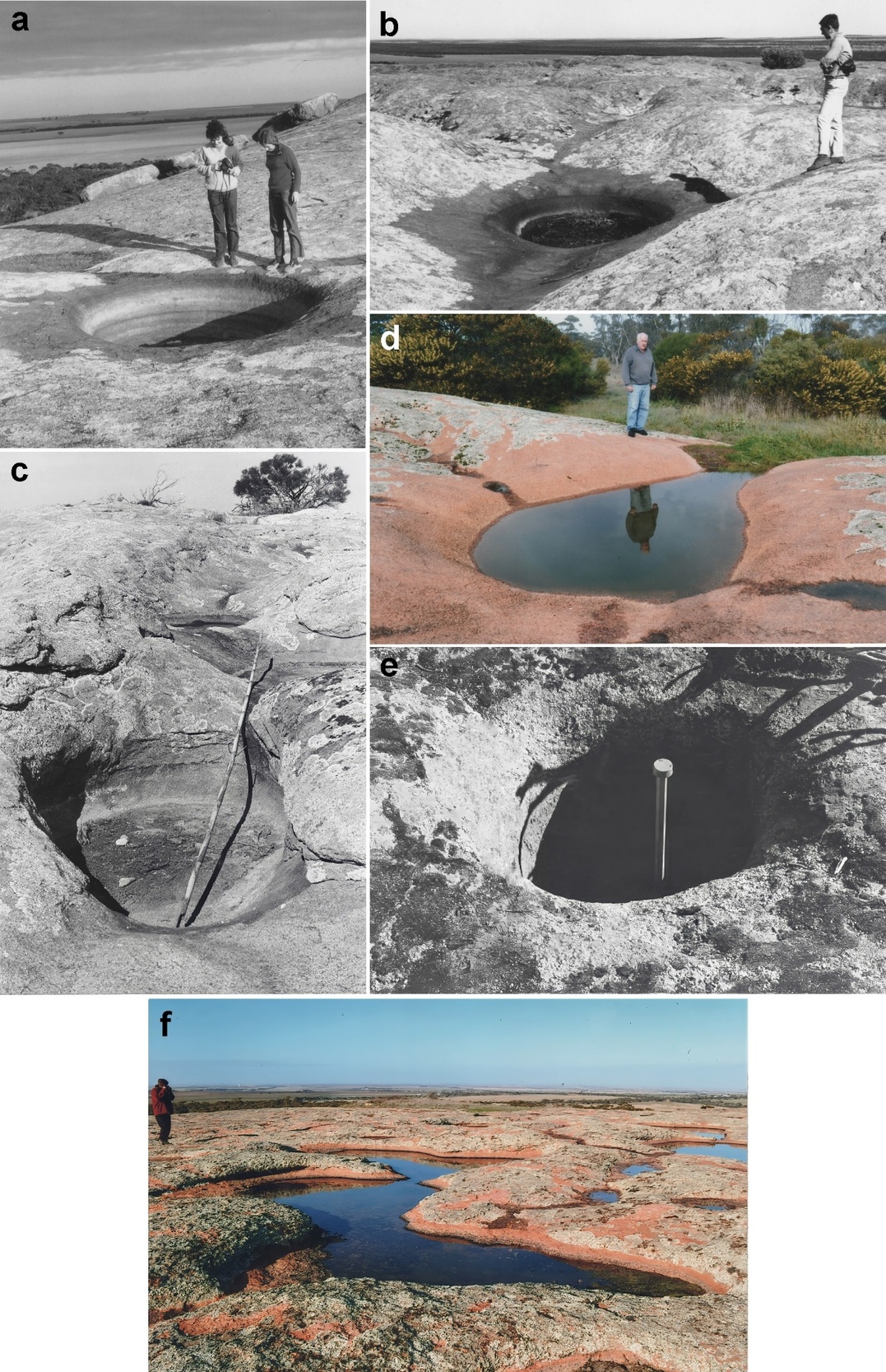
Rock basins or gnammas that store rainfall are well and widely developed on granite outcrops the world over, including north-western Eyre Peninsula (Twidale & Bourne, 1978; Twidale & Corbin, 1963; Twidale & Vidal Romani, 2005, p. 207 et seq.; Timms & Rankin, 2016; Twidale, 2022), and were put to good use. They include ‘bathtubs’, hemispherical pits, cylindrical basins, shallow flat-floored pans, and some armchair-shaped hollows that at times stored useful amounts of water (Figure 2). The value of even small volumes of water is indicated by schemes like that at Kolballa Hill, which was minor and troublesome to maintain, yet was considered worthwhile (Figure 3) for they allowed farming families to keep a dairy cow (milk for children), as well as supporting chickens and domesticated pigs, and even helping maintain a vegetable patch.
At a larger scale, some who gave evidence to the Parliamentary Committee in 1916 remarked, though with reservations, on the potential usefulness of granite outcrops as catchments in conservation schemes. For instance, Mr A.W.H.B. Barnes of Wudinna reported that ‘there are in some places, granite rocks that make good catchments,’ but, he added, ‘there are not very many.’ (SAPP, 1916, p. 42), alluding to the experience of some farmers who had drilled but encountered either saline water or clay derived from the weathering of granite rocks and that did not hold water.
_and_(b)_hemispherical_pits_on_pildappa_rock._(c)_asymmetrical_armch.jpeg)
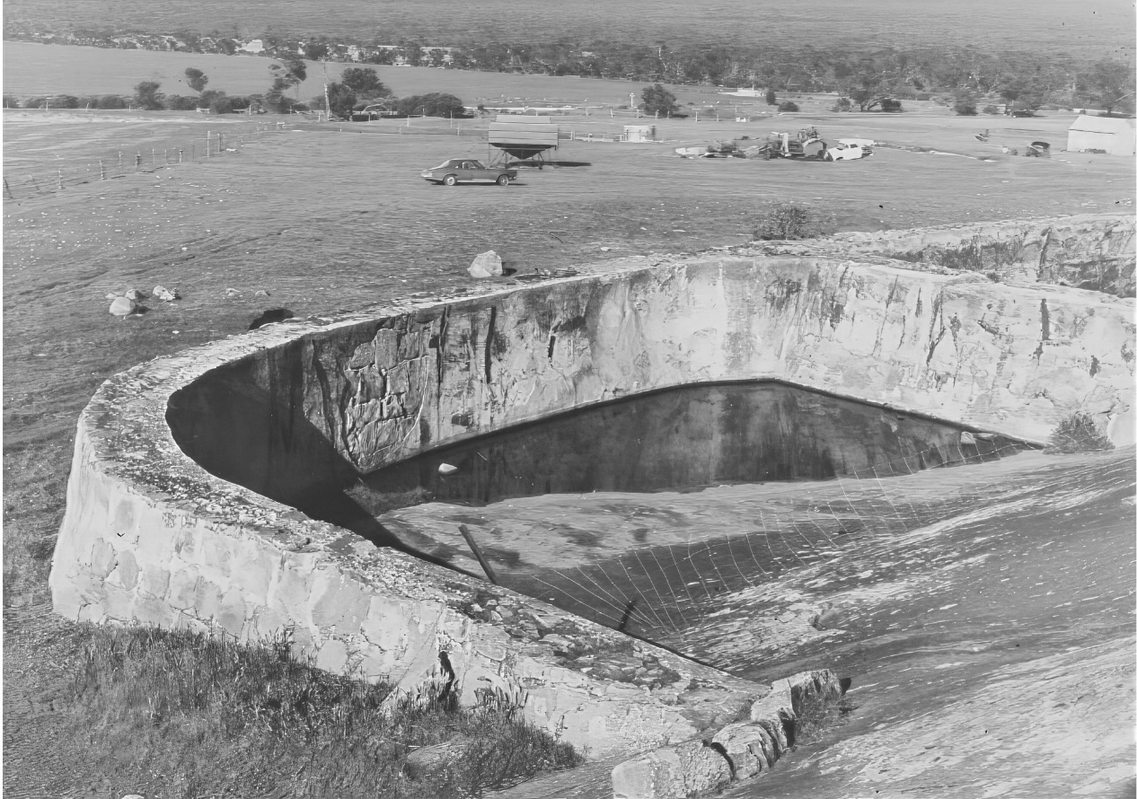
The newly appointed Farm Manager, Mr L J. Cook had a similar experience, though of a different origin, with the conservation scheme he had had constructed in February 1915 at the larger Eastern Yarwondutta Rock. He realised that a reliable water supply was vital to the functioning of the Farm (Cook in SAPP 50, 1916: 49). In particular and in an immediate sense, it was essential to provide an assured water supply for the ten horses he had acquired to help clear, and then to work, the Farm paddocks (Holloway, 2019).
The Yarwondutta Rock East water conservation scheme
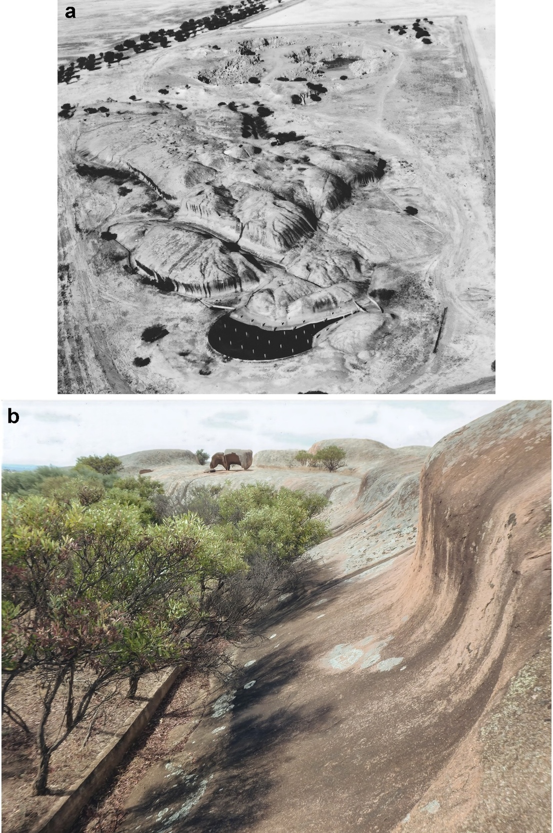
In his evidence to the Parliamentary Committee, Cook referred to this specific conservation scheme. He had tested the depth of soil cover beneath the plains bordering the residual and decided to place his storage basin at the northernmost tip of the outcrop (Figure 4a).
It was the low point of the perimeter of the bedrock exposure so that runoff from the Rock could be diverted to flow there under gravity. Yet the proposed storage would stand high in the local topography so that water could be pumped out and then directed to run under gravity to where it would be needed. An essential feature of the scheme was the construction of low training walls (Figure 4b), so placed that they not only prevented run-off from the bare rock slopes reaching, and being dissipated in, the soil-covered fringing plains, but also diverted the flows so that the water flowed entirely under gravity into a previously prepared storage basin. This second requirement called for an astute eye for country.
_as_seen_from_the_air__from_the_northeast._note_position_of_wate.jpeg)
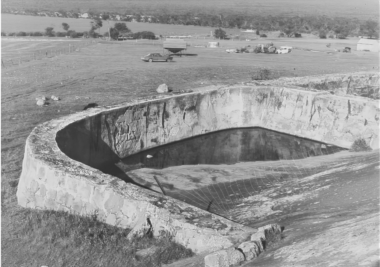
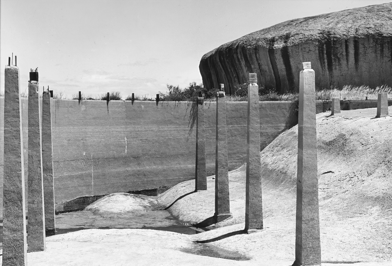
The plan devised by Cook for the Yarwondutta East water conservation scheme appeared to be sound and eminently feasible, but as he stated when giving evidence to the travelling Parliamentary Committee (SAPP, 1916, p. 48), in an excavation close to the outcrop that was intended to serve as a storage reservoir, ‘breaks’ - his apt descriptive term for rock fractures – had allowed the water to soak away. In the event, he resolved the difficulty by having constructed a reinforced outer concrete wall to seal the offending breaks and contain the runoff. He also constructed supports for a corrugated iron roof intended to reduce evaporation and contamination (for instance by blown leaves) (Figure 5).
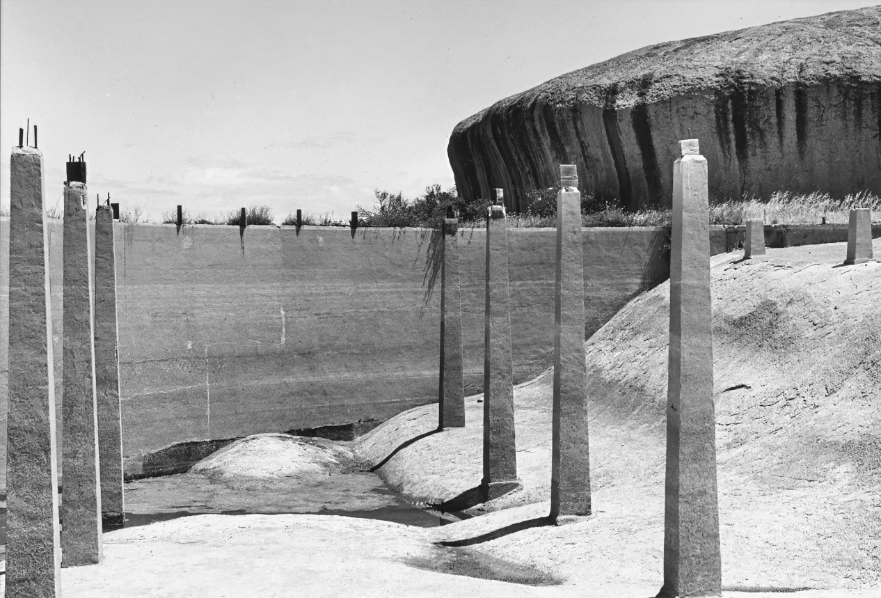
That Cook overlooked the possibility of encountering breaks that would permit water loss was understandable in terms of the times and his experience. Investigations overseas suggested that some granite hills, including prominent inselbergs or ‘island mountains’ (Bornhardt, 1900; Willis, 1934), had developed on compartments of country rocks so massive and lacking open fissures that they were effectively impenetrable to ground water, the major agent of weathering or decay; and this by contrast with the surrounding well-fractured rock that was rotted and thus susceptible to erosional lowering (e.g. Branner, 1896; Falconer, 1911; Logan, 1849). Much later, marginal excavations demonstrated that Ucontitchie Hill, 40-45 km south of Yarwondutta (Figure 1b), is also upstanding because of its massive structure (Twidale, 1964; Twidale et al., 1985).
But Cook could not have been expected to anticipate such structures. To resolve, or at least reduce, the problem of water loss in the proposed storage, the concrete wall he had had built formed the outer limit of a storage basin (Figure 4a) that would hold useful amounts (600 000-700 000 gallons) of rainwater and runoff, but like the supports for a corrugated iron roof, increased costs such that in most subsequent conservation schemes[4] the saved water was conducted from the catchments via lined drains into tanks, typically of half-million-gallon capacity, and located on sound foundations some distance downslope.
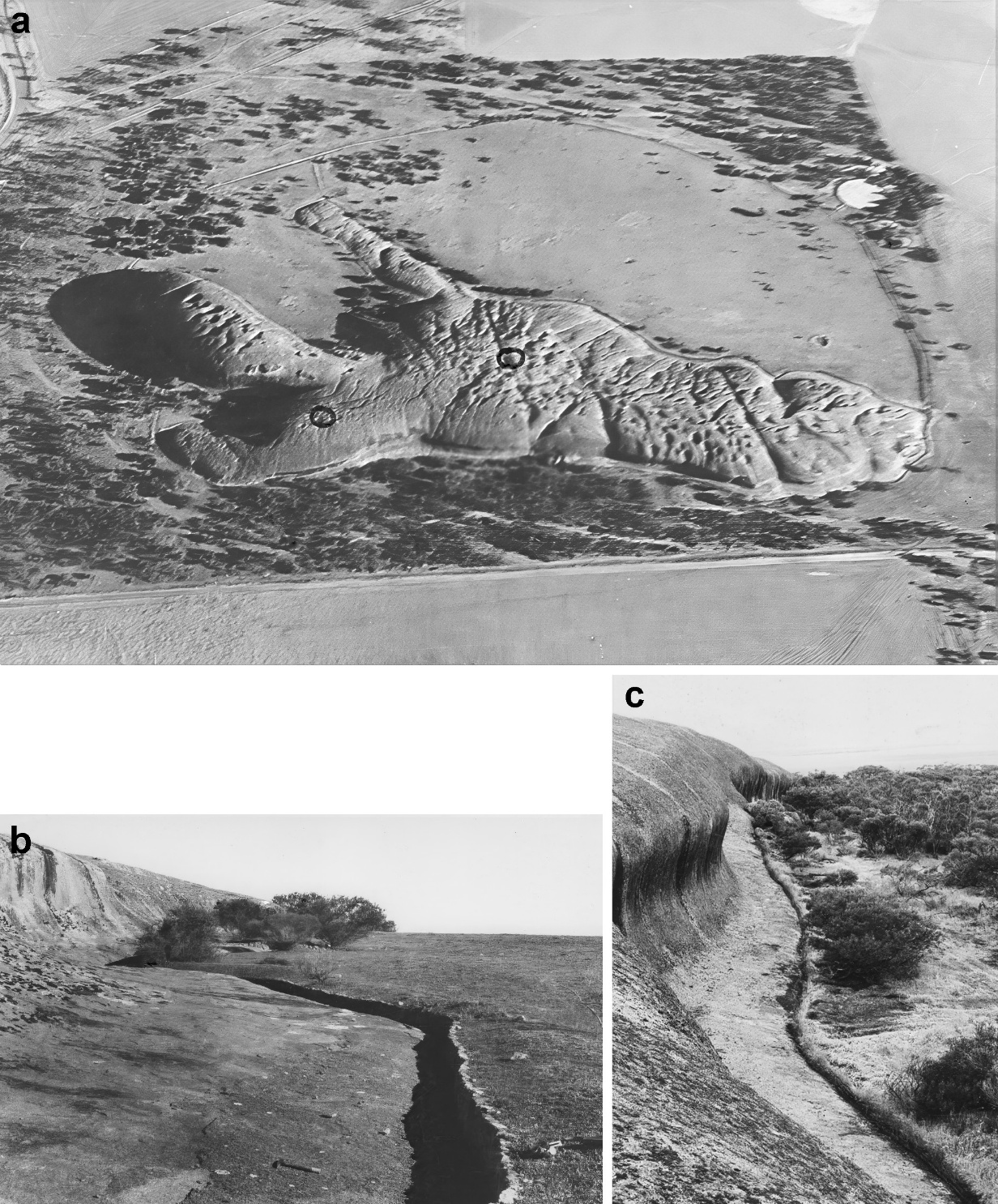
The system constructed at Pildappa Rock (Figure 1b) in 1928 is an example of the revised arrangement (Figure 6a). It was used for many years and was well maintained by the local farmers. Trainer walls were repaired where necessary, and the drains and the inner sides of trainer walls were kept clear of debris. The drains at Pildappa Rock are reasonably direct and still allow flow under gravity (Figure 6b-c), but this requirement plus local micro-relief has necessitated lengthy drains, as for instance, serving the combined Polda Rock-Little Wudinna Hill (Figure 1c) scheme (e.g. Martin, 1968).
_as_seen_from_the_air__from_the_south._note_upper_surface_dimpled_by_pan.jpeg)
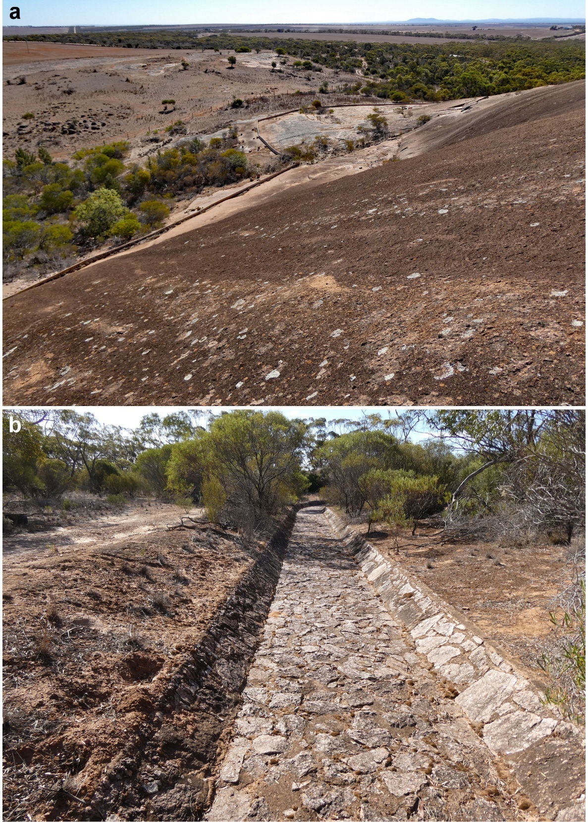
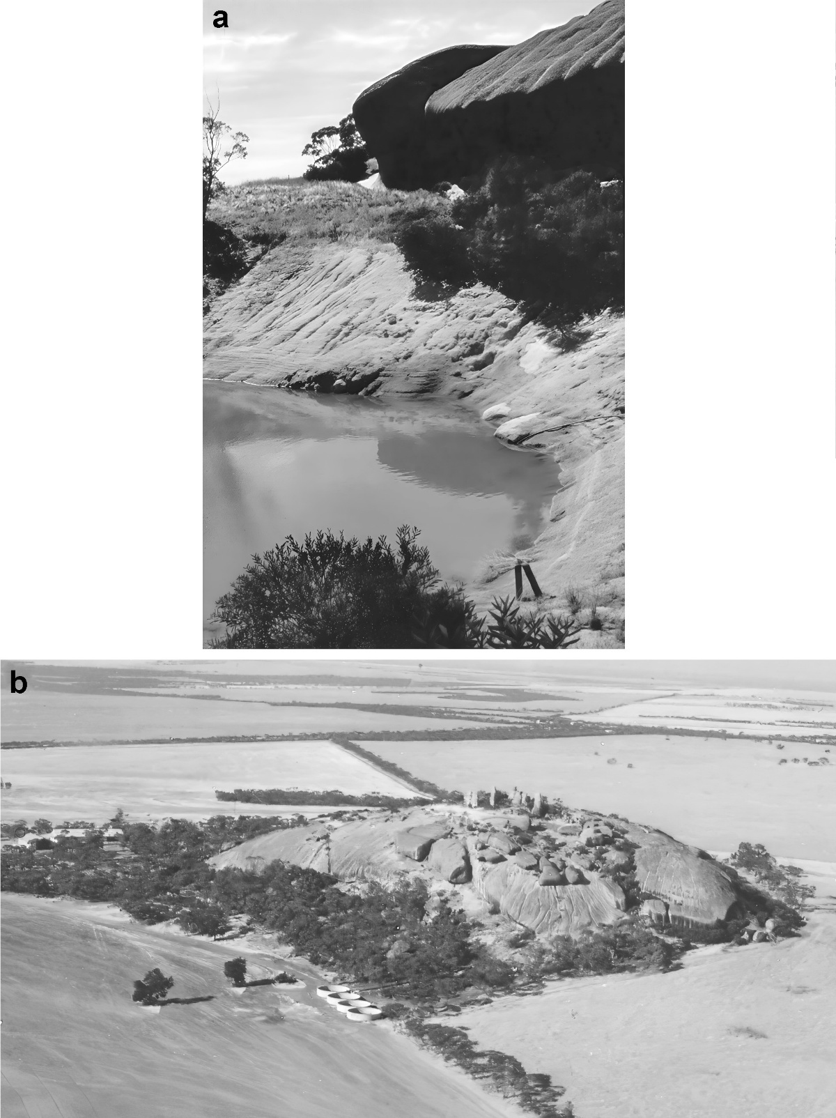
On the west side of Mt Wudinna, the main channel carries runoff from an extensive area of bare rock slope and is both large and elaborate (Figure 7a) while the SW side is served by a drain more than a metre wide and lined with a mosaic of granitic plates (Figure 7b). At Ucontitchie Hill a different solution was devised to reduce water loss in scarp foot storages like that excavated in the northwestern piedmont of the residual (Figure 8a). Training walls on the NE aspect were taken upslope. This reduced the volume of runoff saved and diverted, but, directed to flow into an interconnected group of secure roofed tanks placed on the north-eastern piedmont of the inselberg, was secure (Figure 8b).
_example_of_training_wall_on_eastern_slope_(photo_k-h_seelig)._(b)_drain_mo.jpeg)
_contrast_between_massive_granite_of_the_hill_and_the_closely_fractur.jpeg)
Conclusion
Thanks largely to various Government programmes much of north-western Eyre Peninsula is now reasonably well supplied with potable water and water for stock. For example, Murray River water is pumped to Kimba and the surrounding areas. It was not always so. Government measures went some way to resolve the problems facing agricultural development that were identified by Jones and the early farmers in the Minnipa and Wudinna districts, but water supply was difficult. The Tod pipeline was a boon, but just as it has been claimed that work expands to fill the time available for its completion (Parkinson, 1979), so water needs may have expanded to use that available, and more. It continues to do so, and desalination is, or has been, under consideration, and notably by SA Water.
But the early European pioneer farmers recognised that some of the granite outcrops for which the area is known could serve as catchments in useful water conservation schemes. That constructed on one of the Yarwondutta Rocks at the bidding of Mr L.J. Cook, the first manager of the research and liaison facility, demonstrated what was possible, even to the extent of finding a flaw in the original scheme (leakage along fractures), that could be, and was, avoided in most future constructions.
The various water conservation schemes based on granite outcrops have together far exceeded Cook’s hoped for two million gallons total savings of water. The combined Polda Rock/Little Wudinna Hill scheme of 1919-22 alone includes a 3.25-million-gallon storage of the type Cook originally envisaged. As anticipated by the early farmers, by a manager of vision, and with government support, local granite-based conservation schemes proved beneficial in the establishment and development of wheat and sheep farming on north-western Eyre Peninsula a century or so ago.
Acknowledgments
The authors are grateful to Dr Phil Alderslade for restoring the old photographs and formatting the figures, citations and reference list.
Leonard John Cook (1891-1965). He studied at the Roseworthy Agricultural College where he excelled (Gold Medallist in 1910). After joining the State Department of Agriculture, he was appointed Manager of the Minnipa Farm. He arrived at the site in January 1915 (Holloway, 2019) and, aware of the necessity of an assured water supply for his team of horses, in February, supervised the construction of a water conservation scheme based on the larger of the two Yarwondutta Rocks. He also planned the small settlement that would become the research station and enthusiastically participated in the life of the Minnipa community that was centred on the new railway station (Coleman, 1972). He also met and married an English lady visiting a relative living in the new settlement. On leaving Minnipa, Cook was posted to the Kybybolite Experimental Farm in the South East District of South Australia where amongst other research lines he experimented with the application of super-phosphate (e.g. Cook, 1925). He served on various agricultural committees and boards with distinction and in 1963 received the Roseworthy Award of Merit.
The difficulty of travel was tacitly acknowledged by the arrangements made for teachers appointed to schools in remote areas like Fowlers Bay, to the west of Ceduna, in the years immediately preceding the First World War. An overland journey was not contemplated. Instead, they travelled from Port Adelaide to Fowlers Bay by steamship for the beginning of the school year in January and remained there until mid-December when they returned to ‘the mainland’ (as it was called by the teachers involved) also by sea, to begin the Christmas/ New Year vacation (Mrs N. Cattle, pers. comm. 1970).
Original volumes in gallons, which measure is retained here rather than having a mix of measures. One gallon equals approximately 4.6 litres.
Though not all, for the local geological setting allowed the storage in the large combined Polda Rock/Little Wudinna Hill scheme to be located in the southern piedmont, as theoretically would have been the case at Yarwondutta in Cook’s original plan.